

26 September 2026
Consultation on TP108 2026 has closed. Here are the proposed Auckland rainfall depths, what may change for flood modelling, and what landowners should check now.

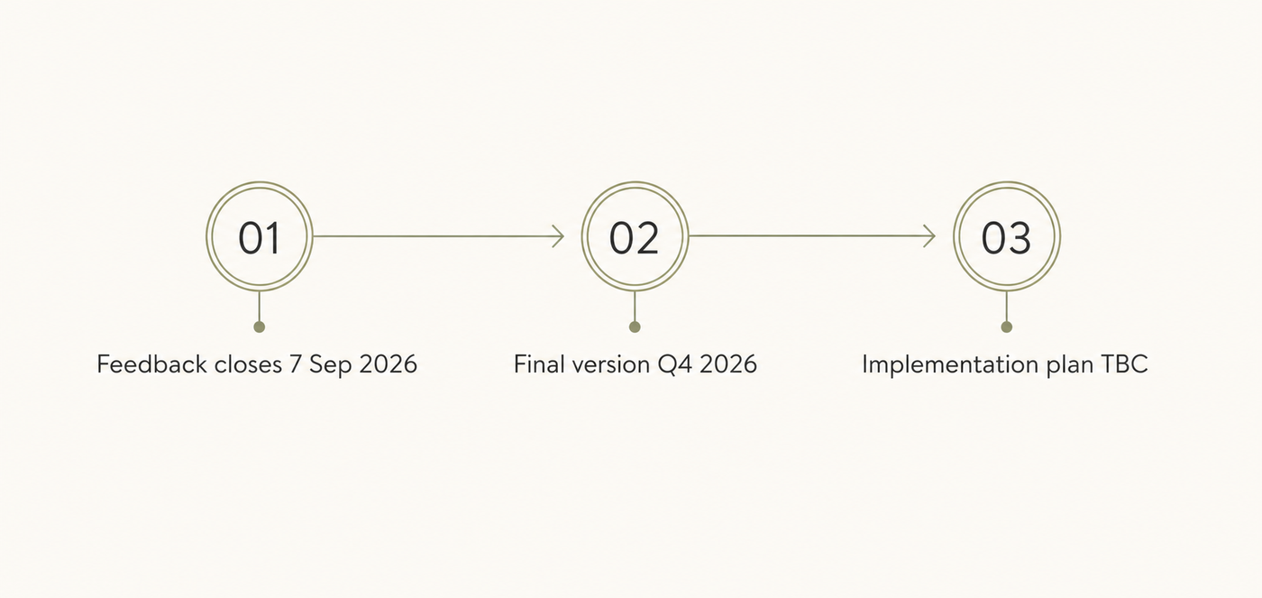
Update, 30 September 2026: Consultation on the proposed TP108 update closed on 7 September. Auckland Council has not yet published revised rainfall figures, a final TP108 update or a confirmed implementation timetable. The figures below remain the August 2026 consultation figures, not adopted design values.
When an engineer models how stormwater leaves your site, the first number they reach for is a rainfall depth - and in Auckland, that number has come from the same document since 1999. Auckland Council is now updating it. If you have a site in feasibility, in early design, or heading toward consent in the next twelve months, put this in front of your engineer before the final version lands, not after.
TP108 sets out how stormwater runoff is modelled across the Auckland region. It is the document behind the numbers that matter on a development site: flood levels, detention requirements, minimum floor levels. Almost every stormwater calculation a project relies on starts from the rainfall inputs it provides.
Those inputs date from 1999. The science has moved a long way in more than twenty-five years - including several storms that rewrote what Auckland thought an extreme event looked like. The document has not.
Auckland Council published a consultation draft of TP108 (2026), and feedback closed on 7 September 2026. It is a partial update, and the document is precise about what that means.
Appendix A (Design Rainfall Maps and Data) has been fully replaced. It supersedes all previous rainfall mapping and the design rainfall depths that went with it, and where anything elsewhere in the document conflicts, Appendix A takes precedence. The rest of the document stands: the hydrological methodology and analysis from 1999 remain valid guidance.
So the method does not change. The numbers going into it do - practitioners are directed to "apply the updated rainfall inputs in conjunction with the existing methodology". On paper that is one appendix. In practice it is the number the whole model is built on.
The old contour maps and their multiple isohyets are gone. In their place are two rainfall zones. Zone A covers most of the region, including nearly all of urban Auckland. Zone B is the higher-rainfall country - around the Hūnua and Waitākere Ranges, the Mahurangi Hills, and high-elevation Great Barrier Island.
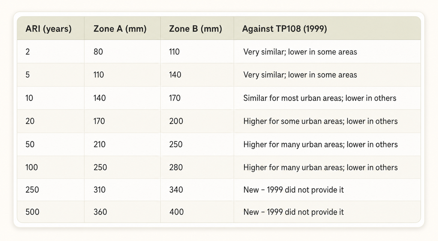
The comparisons in the last column are Auckland Council's own. These are consultation figures and could still move before publication.
The stage where this matters most is the stage where it is easiest to miss - and the pattern in that table decides how much it matters to you.
Read down the right-hand column. Everyday events barely move. The drift grows as events get rarer. Against the worked example inside TP108 itself, the 2-year storm goes from 75mm to 80mm and the 10-year from 130mm to 140mm - but the 100-year goes from 200mm to 250mm, a 25 per cent increase in the figure underneath every flood calculation on that catchment.
So the question on your site is not "what does this cost". It is which event governs the design:
None of these are small adjustments once a project is priced, designed and lodged. They are the kind of change that moves a feasibility from workable to marginal, and the later they surface, the more they cost to absorb.
It can also go the other way, and Council's own comparisons say so: on some sites and some events, the new depths are lower than 1999. The risk is not that every site gets harder. It is not knowing which kind of site you are holding.
Climate change adjustments do not come from TP108. They come from the Auckland Council Stormwater Code of Practice and apply on top of these depths. Council has confirmed the 3.8°C allowance still stands for secondary system design and floodplain mapping, and that this is not double counting - the updated statistics only account for warming already in the record.
Council's published flood maps have not caught up. The flood layers on GeoMaps and Flood Viewer still run on TP108 (1999) rainfall. If you are doing due diligence on a site this month, the flood extent you are looking at is built on the old data. Those layers will pick up the new depths as they are revised in future.
Council's consultation material said the industry could begin preparing to transition. If your project may consent in late 2026 or 2027, ask your engineer to test the current design against the consultation inputs while also confirming which standard Council will apply. Do not treat the draft figures as adopted requirements until Council publishes the final document and implementation plan.
This is a regional change, not a localised one. Every Auckland development site is potentially in scope.
At Creston Property we manage the full development process - feasibility, consenting and build management. Part of that is tracking changes like this one and working out what they mean for a site before money is committed.
We will not pretend everything can be seen coming. Construction is a hard industry, and some costs stay hidden until the ground is open. What early work does is shorten the list of surprises. A rainfall depth published in a public table is a knowable thing - and knowing it at feasibility is a far cheaper problem than meeting it at consent.
That is the distinction that matters here. Some risks can be found early if someone goes looking. Some cannot. TP108 (2026) is firmly in the first group.
If you are working through feasibility on an Auckland site and want a development partner who goes looking, start with a conversation. Get in touch or visit www.crestonproperty.co.nz.
Wondering if your own site could be developed? Run a free land check
We write about what we come across on Auckland development projects, like consenting, feasibility and build costs. New articles go straight to your email.

